I looked this up on Google and this is what I found.
HAAT of Mt. Everest is 8848.86 meters (29031.7 feet).
HAAT of Mt. Everest is 8848.86 meters (29031.7 feet).
That would be height above mean sea level. Height above average terrain is calculated differently:I looked this up on Google and this is what I found.
HAAT of Mt. Everest is 8848.86 meters (29031.7 feet).
Yes. I had built a 2 meter FM repeater as a college project in 1974. To use it, even at my house, I had to file for a separate repeater license from the FCC, apart from my primary and secondary licenses. They required a hand-drawn plot of the elevations at 2, 4, 6, 8, and 10 miles at angles of (IIRC) every 22.5 degrees from the elevation of the base of my antenna (which was on my family's house in Phoenix, at about 1250 feet ASL). I only had to use two maps to get it done, and the FCC blessed it with the callsign WR7AEV. IIRC, those rules were scrapped from the ham regs a year or two later, although the WR calls didn't disappear until 1977 or thereabouts. That was a completely unnecessary pain in the butt, and I'm glad it didn't last long.Just for information purposes, how many here have ever computed HAAT the old fashioned way? Getting down on the floor, pasting 10+ USGS Quadrangle Maps together, drawing major radials on the maps, and finding the elevation points along each radial? I did that once before talking to Peter Moncure and getting his DOS based Radiosoft software. It should be a rite of passage for communication engineering consultants.
")

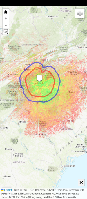
Hopefully the engineer would also be a sherpa....Since we're all radio nerds here, and talking hypotheticals, this thread got me thinking... and wondering what coverage would look like from Mt. Everest.
So... let's say we are somehow able to build a 50 foot tower atop Everest, and run an omnidirectional 100,000 watt FM off of it (yes, I know the number of bays, etc. would have an effect, but this is just a basic exercise.)
Perhaps, not surprisingly, our Everest FM has horrible coverage over most of Nepal, with a ton of shadowing from the surrounding Himalayas. The Nepali capital of Katmandu, about 90 miles away, doesn't get a usable signal. To the north, the sparsely populated Tibetan plateau gets much less shadowing.
However, once you get to the southern border of Nepal into the plains of the Ganges, Everest FM booms into the Indian state of Bihar and portions of northwestern Bangladesh. Coverage in this flatter region reaches some 300 miles in areas.
Now, good luck keeping the thing on the air.
View attachment 11348
Thanks for answering my burning question. I suspected there would be big shadow problems all over the place from all the other Himilayan mountains. But WOW!Since we're all radio nerds here, and talking hypotheticals, this thread got me thinking... and wondering what coverage would look like from Mt. Everest.
So... let's say we are somehow able to build a 50 foot tower atop Everest, and run an omnidirectional 100,000 watt FM off of it (yes, I know the number of bays, etc. would have an effect, but this is just a basic exercise.)
Perhaps, not surprisingly, our Everest FM has horrible coverage over most of Nepal, with a ton of shadowing from the surrounding Himalayas. The Nepali capital of Katmandu, about 90 miles away, doesn't get a usable signal. To the north, the sparsely populated Tibetan plateau gets much less shadowing.
However, once you get to the southern border of Nepal into the plains of the Ganges, Everest FM booms into the Indian state of Bihar and portions of northwestern Bangladesh. Coverage in this flatter region reaches some 300 miles in areas.
Now, good luck keeping the thing on the air.
View attachment 11348
I had a client at my Day job 20 or so years ago. Somehow, we started talking about radio, and it turned out she had been a DJ and Newscaster at a station in a small town in Ohio. She was now a lawyer for a bunch of 501c3s not related to radio. I don't know if it was her undergraduate or law school days, but she went to a college in California, seems like it was somewhere near San Francisco, near some mountains. She got involved with some students who had a low power pirate station in the area where students lived near the college. One day, they drove the signal, and were able to hear it 20 or so miles away in the favorable direction of the terrain. She thought she had done something terribly illegal. I asked her why she didn't do Communications Law. She thought that her pirate radio involvement disqualified her ethically from that branch of Law. I told her that a large percentage of people in radio had done things like that in their youth, and actually developed their interest in radio that way, but she still maintained it disqualified her.Great fun stuff, folks!
@ Schroedingers Cat :
My buddy and I, neither of us anywhere near being licensed or otherwise deigned as 'qualified' to do anything of the sort, applied for an LPFM in that very first FCC window long ago and somehow got a 100 on the FCC test. With a terrific hint from an FCC fellow and a slight change in the filing, we got the CP back in three days. As it sorted out, we were the only ones in the entire county of 160,000 to get a license.
Thing is, lol, we used those big USGS maps -- 30 of them -- to calculate our HAAT. No doubt the FCC snickered and sent our coordinates across the Potomac to Reston and got the figure back in less time than it took us to lay flat the first map. We wound up 50 feet off. Those Ess-Oh-Bees, hi.
@ Huff :
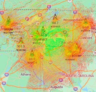
Gotta love that wicked, warped, terrain-effect map! The cx and remoteness of that scene must be very similar to -- probably more problematic in fact -- than the CBC's venture to cover Canada's Northern Exposure tundra with those 40-watt AM relay xmtrs over 50 years ago. Our gang of 4 DXers near JFK Airport in Queens NY heard a total of about two of those TIS stations helping out people mushing to an outpost to shop for dog chow.
What are the color ranges? I'm guessing Green=>70 dBu, Aqua=61-70 dBu, Blue=50-60 dBu, White <50 dBu. Where is K2? Don't say Casper, WY.Since we're all radio nerds here, and talking hypotheticals, this thread got me thinking... and wondering what coverage would look like from Mt. Everest.
So... let's say we are somehow able to build a 50 foot tower atop Everest, and run an omnidirectional 100,000 watt FM off of it (yes, I know the number of bays, etc. would have an effect, but this is just a basic exercise.)
Perhaps, not surprisingly, our Everest FM has horrible coverage over most of Nepal, with a ton of shadowing from the surrounding Himalayas. The Nepali capital of Katmandu, about 90 miles away, doesn't get a usable signal. To the north, the sparsely populated Tibetan plateau gets much less shadowing.
However, once you get to the southern border of Nepal into the plains of the Ganges, Everest FM booms into the Indian state of Bihar and portions of northwestern Bangladesh. Coverage in this flatter region reaches some 300 miles in areas.
Now, good luck keeping the thing on the air.
View attachment 11348
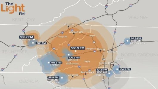
Another good example is 103.3 KRUZ in Santa Barbara - Super Poweres 105,000 watts, and a tall HAAT of 905 meters (2969 feet).
It has been said that KRUZ covers the largest geographic area of any U.S. station, reaching 200 feet into Mexico at the southern end of its coverage (not to be confused with its protected signal contour).

 www.radioworld.com
* Land area coverageOr did it omit "over water" mileage?
WHOM FM transmitter was, and maybe still is, on Mt. Washington in New Hampshire. My father used to listen nightly to Marlin Taylor's Beautiful Music tapes from there in 1972 - 1976 after Alpert owned it. Did not get the WHOM calls until 1976. Use of that site goes back to the Edwin Armstrong days. WMTW FM from about 1958 which comedian Jack Paar owned in the mid 60s for a couple of years and then Paul Herron of Philadelphia. Gardiner Greene had a multiplex background music business on that frequency from 1959 through most of the 1960s out of Laconia NH.James Duncan performed this calculation of the largest FM service areas 25 years ago, so some calls and facilities have changed since then:
View attachment 11396