Do they even make radios that have a reception meter like theres, with 5 bars on it? If anyone has one like this, how does it compare to radio locator? In more general terms, how accurate do you find them? I don't find them that accurate, because in Raymond for example, no Seattle stations are listed as even barely perceptible, yet on the G8, I can get most of the Seattle signals. Also, on Camano Island north of Seattle the Seattle signals, which they list as signal strength 3, are severely multipathed, while Vancouver BC, which they list as 1, sound clear as locals.
-
Get involved.
We want your input!
Apply for Membership and join the conversations about everything related to broadcasting.
After we receive your registration, a moderator will review it. After your registration is approved, you will be permitted to post.
If you use a disposable or false email address, your registration will be rejected.
After your membership is approved, please take a minute to tell us a little bit about yourself.
https://www.radiodiscussions.com/forums/introduce-yourself.1088/
Thanks in advance and have fun!
RadioDiscussions Administrators
You are using an out of date browser. It may not display this or other websites correctly.
You should upgrade or use an alternative browser.
You should upgrade or use an alternative browser.
radio locator
- Thread starter bobdavcav
- Start date
K
K.M. Richards
Guest
In more general terms, how accurate do you find them? I don't find them that accurate ...
I will direct your attention to the disclaimer that appears below their maps:
This image is intended solely for entertainment purposes. Radio-Locator makes no claims as to the accuracy of this information, nor towards its suitability for any intended purpose.
@ Bobcavdav:
A month ago, while up in the Catskills (NY) visiting my kid sister and her tribe for dinner, and for drinks, cards, comeraderie, drinks, quality kitchen-table talk and more drinks, I actually hauled along a radio and spun some dial on a Sunday morning, 7-12-15.
I was just curious as to what would come in on a Grundig S450 'Field Radio' with batteries -- and how it would compare when I got home to the Radio-Locator reception page for 'Woodbourne NY'.
The Grundig S450 is a pretty sensitive and selective $70 rig. It's sonics sound like sh(aving cream) but it wasn't a bad buy.
Radio-Locator's 'Woodbourne NY' coordinates here .......
http://radio-locator.com/cgi-bin/locate?select=city&city=woodbourne+ny&x=0&y=0
..... were about 75% correct on FM.
And gosh-darn -- the Grundig radio DOES have those reception increments for signal strength .... all the way to '5'.
* * * * * *
Forget that AM radio 'selection' offered by Radio-Locator, though. The S450 is a nice radio, but I could only get WVOS 1240 and a faint WJIP 1370. The rest of the dial soundedd like a thousand eggs frying for lunch at a nuclear plant.
Paraphrasing the Todd Rundgren lyrics about Radio-Locator.s coverage maps (which I find kind of pretty accurate) : They may be stupid but they're so much fun ......
I've found Radio Locator to generally be a very good source in showing the coverage areas of AM signals, especially when it comes to directional signals.
And I've liked looking at it so much that many times, I exceed my daily limit of stations that we are allowed to look up.
But my own experience has shown that I can receive some AM signals in the daytime well outside their limit for their 'Fringe'.
For example, 880 WZAB from the Miami area can be heard with a weak signal in the daytime in Daytona Beach. The map has it only going as far north as Ft. Pierce.
http://radio-locator.com/cgi-bin/pat?call=WZAB&service=AM&status=L&hours=D
Some of their Fringe limit lines are on the conservative side.
Lines on the coverage maps are intended to indicate 60, 50 and 40dbu for FM and 2.5, 0.5 and 0.15mv/m for AM. Under certain conditions, it's possible to hear beyond 0.15.
The maps are certainly a reasonable approximation, and give guidance as to what the actual coverage may be.
All that has to be done is a bit of extrapolation. In rated markets, about 95% of the FM at home and at work listening to radio occurs inside the 65 dbu contour. So going about 25% inside the innermost red contour of radio-locator will give a good idea of where most actual listening can occur. For in-car, the range is better... likely between the 55 and 60 dbu contour (there is no data on this as car location is not tracked in Nielsen in the diary markets, and is not segregated from at work in PPM markets).
For AM, in larger metros a 10 mV/m signal is about the minimum for getting ratings at home and at work, with in-car only being a bit broader. In smaller metros and semi-rural areas, the 5 mV/m might be acceptable, although today's CPUs and dimmers and non-incandescent lighting makes that assumption questionable. So the usable coverage of all but rural AMs is about 60% of the inner red contour on the site.
http://radio-locator.com/cgi-bin/pat?call=WGMF&service=AM&status=L&hours=D
is my closest unheard AM station nowadays.
If you draw a line between the circle denoting Hazleton and that designating Shamokin,, I'm right in the middle, just down a bit into that first beige splotch south of the line.
The FCC map I found looks * identical * , in terms of lobes and bearings, to the Radio Locator map. I'm outside the outer blue line, but still : both the FCC and Radio Locator indicate that WGMF sends roughly ~ 800 watts at me. So I don't know whose fault it is that I can't hear an 800 watt station that broadcasts not even 50 miles north of me, lol.
Like other publications, Radio-Locator gets their data from the FCC or the CRTC. Then they give it colours and bugles and glitz and water-path distortion and makes it all look nice. I have nothing but enjoyment looking at their pages.
I would say that FCC prediction methods usually overestimate signal strength both for AM and FM. It looks like you have some hills in between WGMF and your location. Those tend to be associated with conductivity less than M-3, and also block the path of FM and TV signals that cross them. Longley Rice prediction would be more accurate for FM, and measured conductivities for the AM stations in the area might reveal this. People here may disagree, but my experience is that if you really have a measured 50 uV/m AM signal, and no cochannel and adjacent channel interference, you can hear it on a good radio in an electrically quiet location.
I'm not familiar enough with how coverage maps are for AM signals, but I do know that I'd probably give 730 CHMJ a 1 at my place here in Edmonds rather than a 2 as Radio Locator says. However, for fm, there are many stations I can hear from my grandpa's place that the site says you shouldn't be able to get, and of course the example I started this thread out with, signals coming from more than 80 miles both north and south clearer than the stations coming from the southeast due to terrain.
I would say that FCC prediction methods usually overestimate signal strength both for AM and FM. It looks like you have some hills in between WGMF and your location. Those tend to be associated with conductivity less than M-3, and also block the path of FM and TV signals that cross them. Longley Rice prediction would be more accurate for FM, and measured conductivities for the AM stations in the area might reveal this. People here may disagree, but my experience is that if you really have a measured 50 uV/m AM signal, and no cochannel and adjacent channel interference, you can hear it on a good radio in an electrically quiet location.
For FM, aren't the FCC's coverage maps F(50,50) (i.e. you'd have to have an antenna 50 ft. AGL to receive the station clearly 50% of the time)?
F(50,50) curves are for 50 percent of receiver locations 50 percent of the time. But they are based on an antenna height 30 feet (now called 9 meters, but originally 30 feet) AGL. Reception at ground level (or 6 feet/2 meters AGL) can be considerably different than at 30 feet AGL. If you look on FMFool, you can adjust the receiving antenna height, and you will see that some signals are just a few feet below line of sight at ground level, and will markedly increase with antenna height. If you DXed back in the 1960s, 1970s, and even 1980s, this situation was illustrated by the fact that you wouldn't be able to get a signal at all except during exceptional propagation, yet if you had an FM-10 antenna at 30 feet with a decent receiver, you could hear it all the time and quite well. It is estimated that an FM signal with a 10 element directional antenna at 30 feet pointed at a particular station is about 20 dB stronger than a signal at ground level with a dipole or telescoping antenna. Actually, a telescoping 1/4 wave indoor antenna is better than an indoor dipole, since it can be rotated and polarization adjusted for maximum signal. After around 1985, the band started to get crowded, and most stations maximized their facilities for their Class, or in the case of Class Bs and Class Cs, the best that they could get with all the constraints (FAA, land costs, tower costs, zoning, Section 73.207 and Section 73.213 short spacing restrictions, etc.).
Last edited:
R
rbrucecarter5
Guest
Do they even make radios that have a reception meter like theres, with 5 bars on it? If anyone has one like this, how does it compare to radio locator? In more general terms, how accurate do you find them? I don't find them that accurate, because in Raymond for example, no Seattle stations are listed as even barely perceptible, yet on the G8, I can get most of the Seattle signals. Also, on Camano Island north of Seattle the Seattle signals, which they list as signal strength 3, are severely multipathed, while Vancouver BC, which they list as 1, sound clear as locals.
My Pioneer aftermarket radio has a signal strength meter. It seems to be pretty good, and the five bars are definitely logarithmic like you would expect from a true meter.
I was just thinking some of their maps are rather liberal, especially for nighttime signals and their groundwave nulls. That said, they do a pretty nice service for people like us.
Their greatest drawback is the lack of any mechanism to account for limitations to local reception of AM stations at night caused by interference from other stations on skywave skip.
Only a select few AM stations (the class A AM stations on clear channels) are reliably heard beyond the 2.5 mV/m contour (the red contour on R-L maps) at night. A few more are OK out to about the red line (or just inside it) at night (usually older class B stations in major markets like KXSP, WWJ, WTMJ and KOMO). Many of the rest (all class C and most stations that had been daytimers in the past) have only a small fraction of that area, within a few miles of the transmitter.
I guess that, with some computing power, R-L could create a program to measure all the other stations on the channel, calculate the interference level, and generate a green contour to show the area where a station's signal is above the interference at night (called the "NIF")
Another (minor) fault is the total reliance on M3 soil conductivity figures. In some cases, the actual conductivity may be quite different from the reality (e.g. the Traverse City area, all an "8" on the M3 map, though actually conductivity in, south and west of the city is essentially zero). Note this is the fault of the maps. not R-L's.
One great curiosity I have about R-L's coverage maps: I notice several stations' maps on R-L show seemingly outlandish coverage once their signals cross over the border into Canada. Is this always reflecting areas of good conductivity in Canada, or is R-L's system treating anything outside the US as ocean when making these calculations?
All in all, these are nitpicks. R-L maps are usually reasonably accurate and the site as a whole very appreciated here.
Last edited:
Right as rain about the nighttime coverage depictions, IL636. Using the same RxLocator station, only at night :
http://radio-locator.com/cgi-bin/pat?call=WGMF&service=AM&status=L&hours=N
* * * * * * *
As after-dinner DX one night at the in-laws, I tried for WGMF. The relatives live at the NW part of that vertical bowtie that always has demarked Scranton's city limits.
Well, apparently, I had been listening from as close to the main WGMF beam as possible without having my earphones and BVDs catch fire.
But this monitoring was * just * outside the red line. And I heard nothing on 1460.
Nothing. No WGMF. No Rochester. No Albany. Not even a WNAK 730 first harmonic.
* * * * * * *
(I'd hate to be a high school athlete for the town school with that name WNW of Meshoppen. I bet they dont get WGMF at night, either)
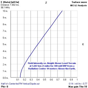
Below is a NEC analysis of fields near the earth for the conditions shown.
For elevations greater than about 2 meters, the field about doubles when height AGL doubles.

So the height takes us up about 11 dB, and a 10 element Yagi takes us up about 7-8 dB, close to the 20 dB often quoted by serious DXers.
Last edited:
An Observation
A 10-element FM Yagi also has more maximum gain at/near its design frequency than a receive dipole of the same polarization, when both the Yagi and the dipole are located at the same elevations AGL -- even down to 2 meters or so.
So the height takes us up about 11 dB, and a 10 element Yagi takes us up about 7-8 dB, close to the 20 dB often quoted by serious DXers.
A 10-element FM Yagi also has more maximum gain at/near its design frequency than a receive dipole of the same polarization, when both the Yagi and the dipole are located at the same elevations AGL -- even down to 2 meters or so.
- Status
- This thread has been closed due to inactivity. You can create a new thread to discuss this topic.