-
Get involved.
We want your input!
Apply for Membership and join the conversations about everything related to broadcasting.
After we receive your registration, a moderator will review it. After your registration is approved, you will be permitted to post.
If you use a disposable or false email address, your registration will be rejected.
After your membership is approved, please take a minute to tell us a little bit about yourself.
https://www.radiodiscussions.com/forums/introduce-yourself.1088/
Thanks in advance and have fun!
RadioDiscussions Administrators
You are using an out of date browser. It may not display this or other websites correctly.
You should upgrade or use an alternative browser.
You should upgrade or use an alternative browser.
92.1 kjmn coverage question.
- Thread starter Syfy
- Start date
If you are using Radio Locator, the innermost red contour is pretty much the outer limits of where any measured listening takes place.In certain parts of the state where the coverage map says that this station should be coming in ok it seems to be very staticy. 30-40 miles outside of Denver. What is the furthest from Denver anyone has picked this station up clearly?
And, even then those contours are very rough estimates. One has to look at a Longley-Rice propagation model which takes into account far more of the terrain variations.
Longley–Rice model - Wikipedia
Good point.If you are using Radio Locator, the innermost red contour is pretty much the outer limits of where any measured listening takes place.
And, even then those contours are very rough estimates. One has to look at a Longley-Rice propagation model which takes into account far more of the terrain variations.
Longley–Rice model - Wikipedia
en.wikipedia.org
This is a Spanish station and I feel its very underrated compared to 96.5 kxpk. They carry the el show de piolin which is a really good show which should be on more stations in my opinion. Its a 42000 watt station. I don't know if it follows the critical hours or if its unlimited 42000 watts.If you are using Radio Locator, the innermost red contour is pretty much the outer limits of where any measured listening takes place.
And, even then those contours are very rough estimates. One has to look at a Longley-Rice propagation model which takes into account far more of the terrain variations.
Longley–Rice model - Wikipedia
FMs don't have critical hours. The have the same power and coverage 24/7.This is a Spanish station and I feel its very underrated compared to 96.5 kxpk. They carry the el show de piolin which is a really good show which should be on more stations in my opinion. Its a 42000 watt station. I don't know if it follows the critical hours or if its unlimited 42000 watts.
Piolín is far more limited in appeal than he used to be when he pretty much burnt out as a morning personality on a big network. He's still entertaining, but nothing like his earlier years, particularly when he started at KSCA and the HBC stations in the early 2000's.
Note: he did overnights on KWIZ in Santa Ana, and he talked to much. So when I had to let go the morning guy there, I figured that if I couldn't keep Piolín quiet, I'd put him where talking was OK. That was around 1994.
And here is what the actual coverage of KJMN looks like. The FCC contours become especially meaningless for real-world use in mountainous terrain.In certain parts of the state where the coverage map says that this station should be coming in ok it seems to be very staticy. 30-40 miles outside of Denver. What is the furthest from Denver anyone has picked this station up clearly?
Attachments
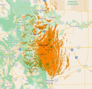
That is a Langly-Rice map based on real terrain. Generally, you have to either have the licensed software or go to a site that will run the map for you if you put in all the station data, including coordinates and other info.Where’d you find this map at?
There used to be a couple of online sites that did that, one in Canada, but they appear to not be doing this any more. Chris or Scott, any suggestion for those maps?
There is no site to my knowledge that produces L/R maps on demand for US radio stations, but you can get an idea of radio coverage in markets by looking at TV stations here:
- Status
- This thread has been closed due to inactivity. You can create a new thread to discuss this topic.