Looks like that map has a major null to the NW which would limit even line of site coverage to about 1% (only 2.5 watts) limiting signal basically anywhere north of Route 287, less than 1 mile away, where there's a bridge over the railroad you can clearly see the tower.
Looks like they are seriously protecting WZZO but sending most of their signal toward WAYV instead.
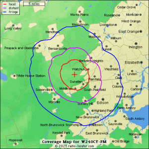
There's a CP that moves it slightly (to New Brunswick)., Lowers it to 124w, with just a big null to the west, otherwise a nicely designed suburban map. (R-L image for CP of W236CT attached, didn't see it on FCCdata)
Unfortunately, I'm not in NJ at the moment, so I haven't had a recent opportunity to do some field testing for signal coverage of W236CT around the area (Not much listening since WOLD was on 107.9 a few years ago).
Tho I was able to test out W240CY from Warren earlier this year, who's 5 watt signal on 95.9 makes it up the mountains just barely above Route 78, or barely down the mountains to about Route 22 before the noise floor & then WRAT starts to take over the channel (Coverage Map Image for W240CY also attached - Mounatinous Terrain Limits Much of the Signal depicted)