The Science Channel's most recent episode of Engineering on the Edge is about a group of special climbers that "risk their lives to repair America's tallest and most inaccessible structures." In this episode (#3) they inspect the cable junctions on Sutro. It features some amazing drone footage and views that will give you chills.
-
Get involved.
We want your input!
Apply for Membership and join the conversations about everything related to broadcasting.
After we receive your registration, a moderator will review it. After your registration is approved, you will be permitted to post.
If you use a disposable or false email address, your registration will be rejected.
After your membership is approved, please take a minute to tell us a little bit about yourself.
https://www.radiodiscussions.com/forums/introduce-yourself.1088/
Thanks in advance and have fun!
RadioDiscussions Administrators
You are using an out of date browser. It may not display this or other websites correctly.
You should upgrade or use an alternative browser.
You should upgrade or use an alternative browser.
Sutro tower climbers
- Thread starter xkxrx
- Start date
Thanks for sending this. I get hundreds of channels from my expanded Xfinity ( Comcast) service, but for some reason, this particular video won't play for me. Apparently my cable package doesn't included the Science Channel. Would've liked to watch this. However, let me just say that San Francisco's Sutro Tower, at 977 feet tall, is an engineering marvel andis used to transmit the signals of about 10 tv stations and 3 FM radio stations. It can be seen from all over the city.
Last edited:
Baltimore's version of the Sutro Tower is this big red monstrosity on TV Hill, from which WMAR, WBAL, and WJZ transmit. The taller thing to the right transmits WBFF. On a clear day with good binocs you can see those towers from the beach in Rock Hall, MD, and you could see them from Memorial Stadium back in the day too.
Do any other cities have towers resembling the Sutro Tower i.e. inverted tripods?
Do any other cities have towers resembling the Sutro Tower i.e. inverted tripods?

Do you mean Candelabra? Here is a Fybush Image of the Baltimore Candelabra.
There is a tower like that in Walnut Grove, CA where the Sacramento TV and Radio stations transmit from and it's to have their signals cover the North San Joaquin Valley cities like Stockton and Modesto.
Note these images are from Fybush tower of the Week. Around the time the article was written KOVR Sacramento aka CBS News Sacramento was transitioning from a contract CBS affiliate from Sinclair to CBS Owned station. Also in the article the Sacramento TV Stations were transitioning to carry DTV signals to meet the 2009 deadline to shut down analog on some of the towers surrounding Candelabra in Walnut Grove,CA.

Last edited:
Back to San Francisco. The Sutro tower is turning 50 years old and it has been modified in 2019-2020 to comply with FCC Repack requirements.


 www.sfchronicle.com

Sutro Tower will sport new antennas — but will still look like ‘the big, ugly neighbor’
Change is coming to the giant red pickle fork.
Last edited:
Mostly San Bruno Mountain.Before the Sutro Tower was built, where did the signals involved eminate from?
I watched the 'End Of Rope' Sutro tower segment on this show, and found it disappointing. Having dealt with tower crews and even climbed in my youth; I can't help but see that this episode was totally staged for TV. The celebrity climber/lead, and his crew clearly weren't regular tower crews. The tower was already rigged with a basket for lifting them, probably intended for more than just inspecting a tensioning cable cross.
More than likely, the Sutro tower was being prepped for paint by real crews. The production company just took advantage of the tower already being rigged to have some actors hang from ropes between levels. They also brought up the hazards of 'parts of the tower showering antenna pieces on the homes below' at least four times, which usually means they're going for the worst case scenario that their viewers would understand.
Actual tower climbing is dangerous and laborious work. Just not sexy enough for TV.
There's a bit of this type of viewing available on YouTube.<...>
Actual tower climbing is dangerous and laborious work. Just not sexy enough for TV.
KFRC-FM Radio Station Coverage Map
There's KFRC 106.9 FM they transmit from Mount Beacon yes there are other locations for radio and TV transmissions in the Bay Area.

 en.wikipedia.org
 en.wikipedia.org
There are also Mount Allison in Fremont, CA and Monument Peak in Milpitas to cover stations that have a city of license in San Jose.
There's KFRC 106.9 FM they transmit from Mount Beacon yes there are other locations for radio and TV transmissions in the Bay Area.
Mount Allison - Wikipedia
Monument Peak (San Francisco Bay Area) - Wikipedia
There are also Mount Allison in Fremont, CA and Monument Peak in Milpitas to cover stations that have a city of license in San Jose.
Attachments
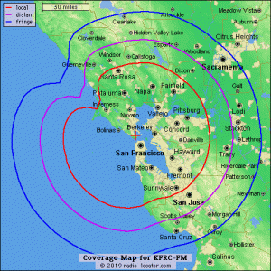
If there is a market where extreme caution should be exercised with those radio-locator maps, it is San Francisco.KFRC-FM Radio Station Coverage Map
There's KFRC 106.9 FM they transmit from Mount Beacon yes there are other locations for radio and TV transmissions in the Bay Area.
Mount Allison - Wikipedia
Monument Peak (San Francisco Bay Area) - Wikipedia
There are also Mount Allison in Fremont, CA and Monument Peak in Milpitas to cover stations that have a city of license in San Jose.
Even the innermost red contour exaggerates enormously the effective coverage which is much more limited due to the terrain.
Yep, a Longley-Rice map would look substantially different.If there is a market where extreme caution should be exercised with those radio-locator maps, it is San Francisco.
Even the innermost red contour exaggerates enormously the effective coverage which is much more limited due to the terrain.
- Status
- This thread has been closed due to inactivity. You can create a new thread to discuss this topic.